Design Thinking & Multi-Actor Approach in NIVA: Step 4 & 5 – Prototype and Test
Tags:
Authors: Christine O’Meara and Dave Hearne, Walton Institute
New IACS Vision In Action (NIVA) a H2020 funded project, aims to develop and implement technologies that will deliver a more seamless Common Agricultural Policy (CAP), in particular through improvements to the key administrative control platform (the instrument for CAP governance) – Integrated Administrative Control System. In Ireland, an interdisciplinary team led by the Department of Agriculture is working on Use Case 4a, working with Walton Institute (application development) and Teagasc (Socio economic research supporting adoption) to develop a geo-tagged photo mobile application which will be used to resolve claim queries.
This fourth blog post in our NIVA mini-series provides an overview of the fourth and fifth steps of the multi-actor approach which are being employed in NIVA. For additional background on the implementation of the approaches employed and NIVA please have a look at the first post in the series here or check out the second and third stages in the process.
The PROTOYPE phase involves the development of successive early versions of the application based on the feedback and insights gained from preceding stages. Ionic, a TypeScript cross-platform native app Framework is used for development and continuous integration and release management is achieved through GitLab. To date, three different engineering releases (ER1, ER2, ER3) of the geotag app have been delivered. Each version has been TESTED with key stakeholders and end users and the test results have informed the next release. Each testing cycle considers both application functionality and user acceptance/ usability. Testers are asked to complete a survey reviewing the application once completed. This tightly coupled and iterative cycle is still ongoing and is the subject of this penultimate blog post in the mini-series.
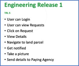
ER1 was completed in late August 2021 and the prototype was uploaded to the Apple App Store and Google Play store. Real end users were recruited by DAFM and Teagasc to complete the tests. A total of 15 users were involved over a 2-week period. The image below summarises key functionality from ER1.
A combination of open ended and multi-choice questions were used to assess the app. Overall, while there were clear areas for improvement, most respondents felt that the app would save time and was relatively straight forward to use. The open-ended questions provided some particularly useful insights into areas where the application could be improved, for example;
“Email screen, better to have a submit button, functionality hidden when in the map, when task completed should change colour.”
“I could only use photos individually.”
These insights informed improved design aspects of the next version of the technology.
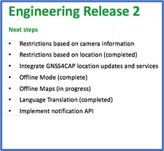
The ER2 prototype was completed and uploaded to the app stores in early December 2020. Recruitment of real end users (farmers and advisors) was again conducted by DAFM and Teagasc with invitations issued to 174 potential participants in Ireland with a representative sample of end users including diverse agricultural activity and locations. Furthermore, 40 testers were involved from Estonia, Lithuania, France, Italy, Austria and Germany. All participants were supported with email instructions, a user manual and webinars. Additionally, email support was available. Given the holiday period, a longer period was allowed for responding to the test requests (deadline mid-January). See below for some of the key functionality in ER2.
Detailed feedback was gathered through surveys and also documents provided by EU testing partners. A high number of respondents gave positive ratings for overall user experience. Specific comments related to ease of use described the app as ‘clear’, ‘very cool’, ‘worked well, very functional’.
There were several suggestions for improvements (in each case from a small number of participants). These included;
‘Was slow to upload one of the pictures’
‘I have no idea if it was uploaded to the system or not. Should be a way to do that’
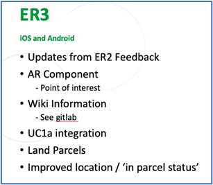
Specific functionality has been delivered through ER3 to respond to items of concern including augmented reality markers to guide photo position, directions functionality and status updates.
Regarding usefulness, again the app was rated positively with some suggestions for improvements. Comments include;
‘It is very useful for farmers to resolve any possible queries with Paying Agencies, without the need for on-the-spot check by PA’
‘It will be very useful if you have a problem with satellite imagery with BPS’
‘Saves having to go back to the office uploading geotagged photos and maps etc.’
‘Found it good bar trying to get to exact point in middle of field with location dot jumping (delayed movement)’
Respondents were also asked their opinion on whether the app would improve communication with the Department/ Paying Agency. This was identified as an area of importance in the multi-actor focus groups and workshops. There was general consensus that the results would be positive in this regard.
Overall, the results are very encouraging with useful suggestions for improvements, many of which are addressed in the latest prototype (ER3). Functionality for this latest release is listed below.
Testing of this version of the app is due to commence imminently (late June 2021). Notably, the app will be used by DAFM for a pilot scheme (REAP) as the key supporting technology with approximately 5,000 participant farmers.


